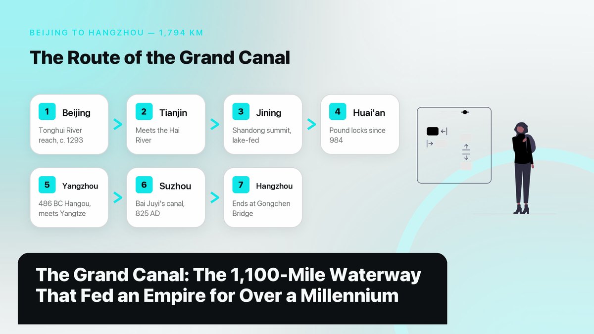
At 1,794 kilometers it is the longest and oldest canal on Earth, and for more than a thousand years this hand-dug waterway between Beijing and Hangzhou fed, taxed, and held together an empire.
Most visitors to China can picture the Great Wall before they land. The country’s other megaproject gets far fewer photographs, which is odd, because the canal carried more economic weight for far longer. The Grand Canal runs flat and brown through farmland and factory suburbs for 1,794 kilometers, roughly 1,115 miles, from Beijing in the north to Hangzhou in the south. It passes through eight provincial-level regions, and boats of one kind or another have used it for close to 2,500 years. The Chinese Academy of Sciences’ geography institute describes it plainly as the longest man-made waterway in the world. Unlike the wall, it was never meant to keep anyone out. It was built to move rice and tax grain, along with the troops that guarded both. On June 22, 2014, at the UNESCO committee meeting in Doha, 27 sections covering 1,011 kilometers plus 58 related heritage sites were inscribed as one World Heritage property. That listing is a recent headline for a very old piece of plumbing, and it has pulled a slow stream of travelers onto the towpaths and museum quays of a waterway that still works for a living.
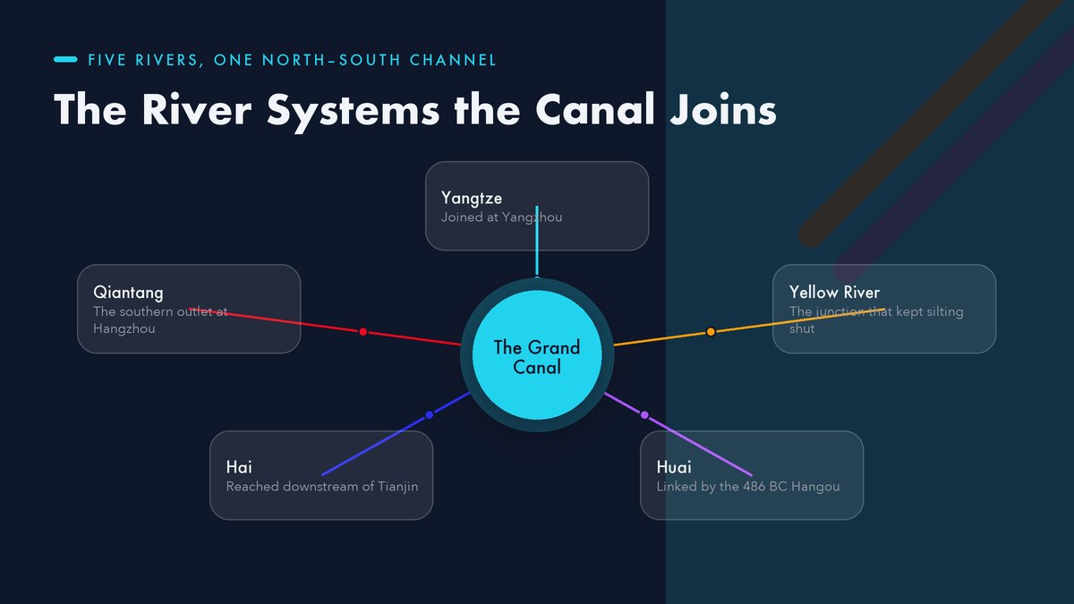
For a sense of scale, consider the two canals most travelers do know. The Panama Canal runs about 82 kilometers, and the Suez Canal about 193. The Grand Canal covers roughly the distance from New York to Florida, and it was dug and re-dug in sections over two and a half millennia, not blasted through in a single modern decade. It also ties five major river systems into a single navigable network, from the Yangtze and the Yellow River south to the Qiantang. That river-junction role, more than its length, is what made it the backbone of imperial China rather than a monument to one emperor’s ego, although it has served as both.
In this article
Why China Needed a River Running North
Geography set the problem first. Almost every major river in eastern China runs west to east, and that shapes everything about the canal’s job. The Yangtze, the Yellow River, the Huai, the Hai, and the Qiantang all flow toward the Pacific along their own valleys. That’s fine if you want to float downstream within one valley. It’s useless if your capital sits 1,700 kilometers north of the rice surplus. The south grows the grain; the north keeps the throne. From the Han dynasty onward, every emperor who ruled from Chang’an, Kaifeng, or Beijing faced the same arithmetic. Feed a million people in the capital region or watch the dynasty crack. No road network of that era could move rice at that scale, at least not without feeding most of it to the pack animals along the way.
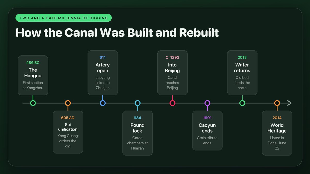
The first recorded piece of the answer appeared in 486 BC. King Fuchai of the state of Wu ordered a canal dug near modern Yangzhou to move troops and supplies north toward his wars with the state of Qi. That ditch, called the Hangou, linked the Yangtze basin to the Huai River. It also gave Yangzhou the position it still trades on today, sitting where the canal meets the Yangtze. Other states cut their own short canals over the following centuries, but the pieces stayed separate. They were regional tools for regional wars, until an emperor with a unified empire and an enormous appetite for public works decided to bolt them together into a single system.
That empire was brand new in 605 AD. China had spent roughly three centuries divided between successive northern and southern dynasties, and the Sui had only just put the pieces back together. A canal that stitched the agricultural south to the political north wasn’t a luxury project for Emperor Yang Guang; it was the physical wiring of the unified state. The Yangzhou museum’s exhibition texts point out that this was the only major canal in Chinese history dug and operated by the central government specifically to secure grain transport and hold the country together. Private trade used it too, of course, but in practice every boat on it floated under imperial rules and past imperial granaries.
From a 486 BC Ditch to an Imperial Artery
One emperor, six years of digging, and a canal that made and broke the Sui dynasty
The unifier was Emperor Yang Guang, the second ruler of the Sui dynasty. In 605 AD he ordered the great excavation, and according to the Ministry of Culture’s heritage pages, the project was essentially complete by 611. Six years of coordinated digging tied the capital region around Luoyang to Zhuojun near modern Beijing in the north and to the Hangzhou region in the south. The standard histories count the conscripted workforce in the millions, though no two chroniclers agree on a figure. The canal’s cost in lives is one reason Emperor Yang’s reputation never recovered, and the Sui dynasty itself collapsed in 618, barely a decade after the last spadeful. The canal outlasted the dynasty that built it. It became what those same heritage pages call the main transport artery between north and south China, and it stayed that artery through every dynasty that followed, the Yuan rerouting it and the Ming and Qing refining it but never replacing it.
Later dynasties kept re-routing the northern half, usually to fit wherever the capital had moved. The Tang and Song ran the system through Luoyang and Kaifeng, which is why the Huiluo Barns, a Sui-era state granary complex excavated near Luoyang, sit on the World Heritage list as a witness to that middle route. When the Yuan dynasty made Beijing its capital in the 13th century, Kublai Khan’s engineers skipped the Luoyang dogleg entirely. They cut a straighter line across the Shandong hills, and around 1293 the astronomer-engineer Guo Shoujing finished the Tonghui River, the last stretch that brought grain boats inside the walls of Dadu, as Beijing was then called. That Yuan alignment is the spine of the canal you can trace on a map today.
| Period | Capital | What changed on the canal |
|---|---|---|
| Sui, 581–618 | Luoyang | 605 order to dig; by 611 the unified north–south artery was open |
| Tang–Song, 618–1279 | Chang’an, Kaifeng | Middle route via Luoyang; first pound lock built in 984 |
| Yuan, 1271–1368 | Dadu (Beijing) | Straight cut across Shandong; Tonghui River into Beijing c. 1293 |
| Ming–Qing, 1368–1912 | Beijing | Caoyun fleets at their height; grain tribute converted to silver in 1901 |
“When the Grand Canal was navigable, the empires were prosperous; when the empires declined, the Grand Canal was abandoned.”
The Hardest Part: Water Won’t Climb a Hill
The engineering puzzle behind the canal’s UNESCO status isn’t length but altitude. Somewhere in southern Shandong, the waterway has to cross a low ridge. It climbs out of one river system and drops into another, and every boat making the full journey had to be lifted and lowered through that divide. The Chinese solution, refined over centuries, was the pound lock, a stone-walled chamber with gates at both ends that fills to raise a boat or empties to lower it. The device is usually credited to the Song official Qiao Weiyue, who built a set of gated chambers near Huai’an in 984 AD to replace the older double slipways, which were slow and hard on hulls. The canal’s technical history reads like a catalog of early hydraulics. Weirs bled off floodwater and dykes of rammed earth held the banks against the Yellow River, while reservoirs fed the summit level through the dry northern summers. The whole course is still described in seven named segments, from the Tonghui River in Beijing to the Jiangnan Canal that slides into Hangzhou.
Water supply, not digging, was the constraint that shaped the route. The canal doesn’t carry its own water for most of its length; it borrows from rivers and lakes. That’s why the Yuan engineers hugged the eastern lowlands and fed the Shandong summit from the lake chain around Nansi Lake instead of tunneling through the hills. When the Yellow River shifted or silted, as it did catastrophically more than once, the canal choked with it. Whole sections had to be re-cut in new beds, and the heritage listing notes that some stretches visitors walk today were rebuilt in the last century directly on top of the silted original.

The Grain Fleets Ran on Paperwork
What moved on the water was only half the system; the other half was administration. The canal carried the Caoyun, the imperial grain-tribute machinery, an official monopoly that collected tax rice in the south and moved it north in state fleets to imperial granaries, punishing any official who let so much as a sack disappear. In the Ming dynasty, the central government owned more than 16,000 transport ships. A China Daily feature on the canal notes that a standard fleet ran about 30 ships under its own flag, with rigid schedules for daily distance, at least on paper. At the height of the system, the annual quota of tribute grain ran to roughly four million shi. Depending on the conversion you use, that’s somewhere in the neighborhood of 300,000 tons of rice a year, all of it moved by sail and tow rope over the Shandong ridge.
Because grain is easy to steal, the bureaucracy invented anti-corruption devices that sound modern. In the Qing dynasty, inspectors from each agency along the route signed a folding fan, one signature per agency, and matching signatures were stamped directly onto the grain bags. When a shipment arrived short or moldy in Beijing, officials could unfold the fan and see exactly whose inspection had failed. The same China Daily feature describes the excavated Huiluo Barns near Luoyang, where archaeologists uncovered the storage end of the pipeline. It was a walled granary city on the World Heritage list, positioned to receive river barges and meter rice out to successive capitals for well over a thousand years.
What the Canal Built on Its Banks
A river of government grain creates towns the way a magnet drags iron filings. Yangzhou grew rich at the Yangtze junction as the transfer point between sea-going junks and canal barges, and its merchant wealth paid for the gardens and teahouses the city still sells tickets to. Tianjin’s Yangliuqing district gave its name to a woodblock-print tradition that Ming artisans built with fine paper and dyes shipped up from the south. It’s one of more than 400 canal-related practices now on China’s national intangible-heritage list. The Venetian traveler Marco Polo saw the region in the 13th century and described Hangzhou as, in the words of his book, beyond dispute the finest city in the world. Whatever you make of that claim, the canal was a fair part of the reason the valley could afford its splendor.
The old proverb quoted in the Yangzhou museum’s exhibition texts says it best. When the canal was navigable, the empires prospered; when the empires declined, the canal was abandoned. The China Grand Canal Museum, which opened in Yangzhou in June 2021, takes that proverb as its organizing idea and tells the story across permanent galleries built around a full-sized boat and an electronic sand table of the historic course. It has quickly become the best starting point for a visitor who wants the canal’s whole arc in one air-conditioned afternoon, and in practice it’s the one stop where the engineering, the grain fleets, and the riverside culture all share a single roof.
Floods, Silt, and a Second Life
When the decline came, it arrived as a river, the Yellow River. In 1855 it burst its banks in Henan and shifted to a new course running north of the Shandong peninsula. The flood smashed the hydraulic system around Huai’an and dumped sediment into stretches that had worked for a thousand years. Within decades, sea shipping and then the new north–south railways took the long-distance freight the canal could no longer guarantee. In 1901 the Qing court formally converted the grain tribute to silver, which ended the Caoyun. By 1949, by the Chinese Academy of Sciences’ account, only a small section of the whole system was still navigable.
The revival is a modern one, and it’s incomplete in an interesting way. South of the Yellow River, the canal never really died. The Jiangsu section now handles 1,000-ton barges across more than 400 kilometers of connected waterway, which makes the southern third one of the busiest freight corridors in the country. Since 2013, the eastern route of the South-to-North Water Diversion Project has pumped water up the old canal bed to supply Beijing and Tianjin. The capital region drinks from the same channel its emperors ate from. The northern sections, meanwhile, survive mostly as heritage: dry beds and rebuilt locks, museum parks and towpath walking trails. That’s why the 2014 World Heritage listing covers only the 1,011 kilometers of channel that still tell the story, a selection process driven by a nationwide city alliance of canal towns and debated for years before the Doha decision. One waterway, two afterlives, a working freight canal in the south and a curated memory in the north.
Seeing the Canal for Yourself
A traveler who wants to read the canal’s whole biography can do it in three stops. In Hangzhou, the Gongchen Bridge area marks the southern end of the historic course, with a museum quarter and night-lit quays where you can stand at kilometer zero of the 1,794. Suzhou offers the prettiest surviving stretch. The Shantang Canal there was dug in 825 AD by the poet-governor Bai Juyi to ease flooding and open the city’s west, and it still anchors a seven-li street of teahouses, about two and a half miles long. Yangzhou gives you both the museum and the water, with sightseeing boats running routes the state tourist bureau first opened back in April 1981 between Wuxi, Yangzhou, and Hangzhou. Canal cruising in China is older than most people’s idea of a package tour.
The ride itself tells you why the canal towns grew where they did. Between Suzhou and Yangzhou the channel narrows into tree-lined cuts, passes under stone arch bridges built low enough that masts had to be lowered or sails dropped, and slides past brick warehouses whose loading doors still open a few feet above the waterline. None of it is staged scenery; it’s the working infrastructure of the Jiangnan Canal, and although the cargo is containerized and diesel-towed now, the sightlines the Sui engineers created are mostly intact. Spring and early autumn are the comfortable seasons on the water, unless you specifically want the Mid-Autumn lantern crowds at the Hangzhou end of the route.
The practical shape of a visit follows the freight, so go south of the Yellow River. North of Jining, what you visit is archaeology rather than a working waterway. It’s fascinating, but you walk it like a ruin instead of riding it like a river. The living water, the barge traffic, the museum boats, and the old towns that grew up on grain money are all in Jiangsu and Zhejiang, where the empire’s lunch money actually moved. Give the canal two days in a Jiangnan itinerary and, unless the weather turns, it repays the detour. Give it a week and you’ll start measuring other rivers against a waterway that was moving tax rice through gated locks roughly four centuries before Dutch engineers built Europe’s first pound lock in the 1370s.
Figures and dates follow the canal’s UNESCO World Heritage nomination as summarized by China’s Ministry of Culture, the Chinese Academy of Sciences’ Institute of Geographic Sciences, and the China Grand Canal Museum. For another ancient route that moved more than goods, see our guide to the Silk Road revisited.