No structure on earth carries more weight per brick than the Great Wall, and no structure is so routinely misunderstood. It isn’t a single wall, it wasn’t built in one dynasty, and the parts you’d visit from Beijing are mostly younger than the cathedrals of Europe. What twenty centuries of Chinese states actually built, and why, is a better story than the legend.
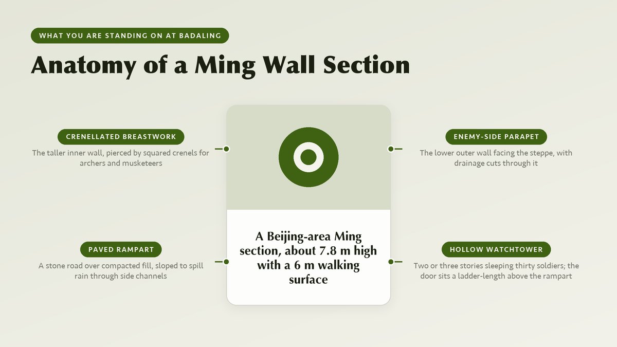
Stand on the ramparts at Badaling on a summer morning and the masonry seems to run to the horizon in both directions, folding over ridge after ridge until the haze swallows it. The wall at this section stands about 7.8 meters (roughly 26 feet) high, and its walking surface runs about 6 meters (20 feet) wide. Ming builders claimed five horses could ride that surface abreast, and every guide still repeats the claim. Badaling was the first stretch opened to tourists, in 1957, and it remains the busiest single heritage site in the country. Foreign dignitaries began posing there in the 1950s, and the section has since hosted well over 200 heads of state and government. It also anchors the most durable misconception in travel writing. The wall you see from Badaling is one restored Ming-dynasty section. The 2012 survey by the State Administration of Cultural Heritage measured the whole defense system at 21,196.18 kilometers, about 13,170 miles, once every wall, trench and natural barrier is counted in. You can’t see that from space with the naked eye, despite the persistent claim. Astronauts in low orbit report that even Badaling is hard to spot without knowing exactly where to look.
The real numbers beat the myth, because they describe an engineering program that outlasted most of the governments that funded it. More than twenty dynasties and rival states raised wall lines somewhere along China’s northern frontier between roughly the 7th century BC and the 17th century AD. Each built for its own enemy, budget and terrain. Chinese itself calls the structure the changcheng, simply the “long wall”; the grander Wanli Changcheng, the “10,000-li long wall,” works out to something like 5,000 kilometers, which tells you the name was always partly poetry. What follows replaces the postcard version with the one a patient archaeologist would give you: who built which wall, how the work was done, what survives, and which sections deserve your daylight.
In this article
Twenty Centuries of Walls, Not One
The earliest walls predate the empire itself by three centuries
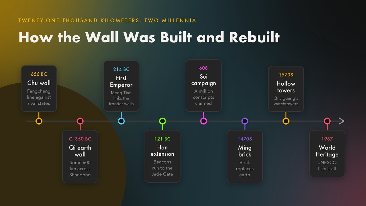
The oldest wall lines belong to the period historians call the Spring and Autumn era, when a patchwork of rival states fought across the Yellow River plain. The state of Chu built a defensive line called the fangcheng, the “square wall,” by 656 BC according to the Zuo Zhuan chronicle, which makes it older than the Roman Republic’s first roads. The state of Qi, on the Shandong peninsula, raised its own wall of rammed earth in the mid-4th century BC. Surveys of the surviving Qi line put its original length at about 600 kilometers (370 miles), which made it the longest wall built before imperial unification. None of these were “Chinese” walls in the modern sense. Each state built against its neighbors, and the lines ran whatever direction the politics required.
Everything changed in 221 BC, when the state of Qin swallowed its last rival and the First Emperor unified China. Within a few years he ordered the general Meng Tian north with an army usually given as 300,000 men. Meng Tian’s orders were to push back the Xiongnu confederation and link the existing Qin, Zhao and Yan frontier walls into one continuous line. The project consumed hundreds of thousands of laborers over a decade and became, in later legend, the archetypal act of tyranny, the wall under which Meng Tian himself was said to have wept. What the First Emperor actually created was a rammed-earth frontier, not the brick wall of postcards. In the dry northwest, sections of Qin and Han wall survive to this day as eroded ridges of packed loess, looking more like raised roads than fortifications. The Han dynasty extended the line dramatically after 121 BC, when the campaigns of the young general Huo Qubing broke the Xiongnu’s hold on the Hexi corridor. Han walls and their beacon towers then ran the full length of the Gansu corridor toward the Jade Gate, and Silk Road caravans traveled under their protection. The wall system became, in effect, the customs fence of the early Silk Road.
Later dynasties repaired, abandoned and rebuilt the frontier as their fortunes shifted. The Northern Wei, Northern Qi and Sui all pushed laborers back to the line between the 5th and 7th centuries, sometimes at ruinous cost. A Sui chronicle claims over a million workers were conscripted for the 608 construction season alone, a number historians treat as bureaucratic exaggeration but revealing all the same. The Tang largely replaced wall-building with military governors and marriage alliances, the Jin dynasty maintained an earthwork “border trench” against the Mongols in the 12th century, and then the Ming, from 1368, committed to the program on a scale no predecessor had attempted. The crenellated brick wall of your imagination is almost entirely a Ming product, built and rebuilt between the late 14th and the late 16th centuries. The overview of the Wall’s dynastic layers traces this sequence in detail, and it’s worth a read before any visit, because the section you stand on tells you which century you’re in.
Who Actually Built It, and How
Soldiers, peasants and convicts, working in the building season
The workforce was never a standing corps of professional masons, because no Chinese state could afford one for a project measured in decades. Ming records describe three streams of workers. Garrison soldiers built in rotation between patrols; civilian households were conscripted by quota from the northern provinces; convicts served out sentences at the wall, and some had their families resettled to the frontier posts they built. Work followed the agricultural calendar and paused for spring planting and autumn harvest, which is one reason a given campaign could swallow a generation. Deaths were common enough to lodge the wall deep in Chinese folklore as a place where buried bones outnumber bricks. A Ming-era tablet at Xifengkou records that the dead were collected and cremated rather than left in the fill. The detail is grim, and it’s also administrative, because someone was keeping count.
Materials followed terrain with a pragmatism that modern project managers would recognize as cost control. Where the line crossed mountain country, as it does around Beijing, builders quarried local stone and fired brick in kilns raised within hauling distance of the wall itself; Ming-era kiln sites are still being excavated along the line. Where it crossed the flat loess plains and the desert, earth was the only sensible option. Workers there built by ramming: wooden forms were set, and layers of earth, gravel and sometimes rubble were pounded inside them with stone-tipped pestles until the mass hardened like concrete. The most remarkable recipe comes from the Ming brick sections. Mortar analyses by a Zhejiang University team under Zhang Bingjian, published in 2010, found an organic additive in surviving samples. The additive was amylopectin, the sticky component of glutinous rice, mixed into slaked lime. That mortar has held bricks in place for five centuries and is now cited in conservation science as one reason the Ming wall outlasted the earlier earthwork versions. Conservationists still invoke the recipe when they repair Ming brickwork today.
The wall held because of what ran behind it: garrisons, granaries, signal towers and roads, all feeding a defense in depth.
Guidebooks skip that infrastructure, but the Ming exchequer didn’t, because garrisons, granaries, signal towers and supply roads absorbed most of the system’s cost. The Ming didn’t try to man every kilometer of wall, since no dynasty could. Instead they split the northern frontier into nine great military regions, the zhen, each under a commander with his own budget and wall quota. Along the Beijing-region sections the regions built roughly 25,000 watchtowers, most of them “hollow” towers developed in the 1570s under the general Qi Jiguang, who had refined the concept fighting wokou pirates on the coast a decade earlier. A hollow tower slept and fed a unit of about thirty soldiers, stored weapons and grain, and gave archers a raised firing platform, replacing the older open beacon mounds. Between towers, the signal chain did the real work. Smoke rose by day and fire by night, with Ming regulations prescribing one beacon-load of wolf dung for a small incursion and several for a major raid, so a commander reading the skyline could estimate the size of the force he faced. By relay, a warning covered the 700 kilometers (about 435 miles) from the frontier to Beijing in a day or two. The towers did that work; the masonry bought the time.

The Anatomy of a Ming Wall Section
A cross-section worth understanding before you visit
Knowing how a Ming section is put together changes what you notice on the ramparts. The walking surface is a paved road over a compacted fill. On the enemy side stands a low parapet; on the inner side, a taller breastwork pierced by squared crenels that archers and, later, musketeers fired through. Drainage matters more than tourists expect. The paved surface slopes gently, and channels cut through the parapet spill rainwater off the fill, because a soaked earthen core in a Beijing winter would freeze, heave and split the masonry, which is exactly what has happened wherever the drainage was neglected. Below the ramparts, watchtowers interrupt the wall line every few hundred meters, set on high ground where their sightlines overlap. A standard Beijing-area tower rises two or three stories, and its only door sits a body-length above the rampart; a ladder, hauled up during an attack, was the original way in.
The towers also explain the wall’s real military logic, which was delay and observation rather than absolute exclusion. No medieval barrier stopped a determined army forever, and the Ming knew it. The wall’s job was to slow horsemen at the passes, force them onto ground the defenders had chosen, and buy time for the garrisons to concentrate. When the system worked, as it mostly did through the 16th century against Mongol raiding parties, the raiders found the passes shut and relief columns already marching. When it failed, it failed politically: in spring 1644 the Manchu forces came through Shanhaiguan after the turncoat general Wu Sangui opened the gate, and the wall spent the next two Qing centuries as a symbol rather than a working defense. Neglect followed, which is why so much of the Ming wall stood ruined when foreign visitors began photographing it in the 19th century.
Where the Wall Actually Runs
From the old dragon’s head in the Bohai Sea to the last fort in the Gobi
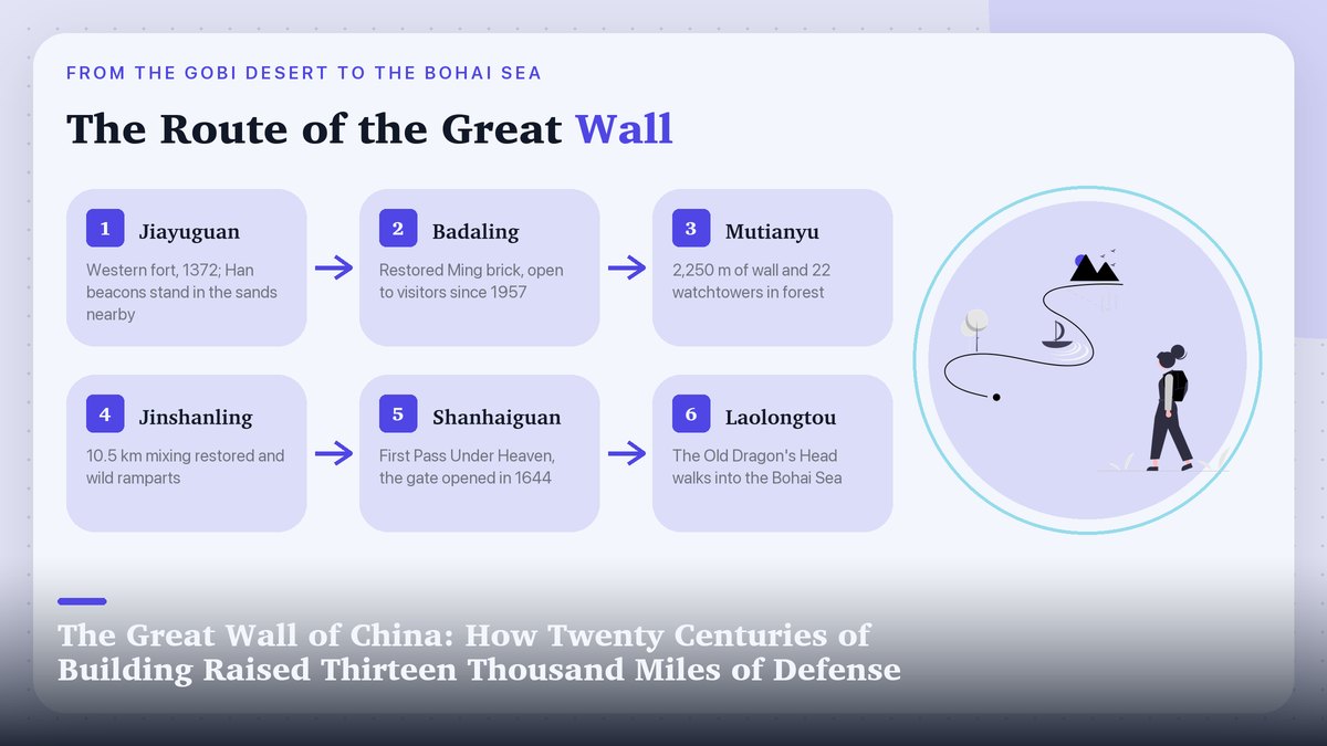
The wall’s two traditional endpoints sit more than 2,300 kilometers (about 1,430 miles) apart once the defense line is followed properly. In the east, at the Bohai coast near Qinhuangdao, the masonry walks straight into the sea at a spot called Laolongtou, the Old Dragon’s Head, built under the general Qi Jiguang in the 1570s. A few miles inland stands Shanhaiguan, the “First Pass Under Heaven.” Its gate tower framed every campaign between Manchuria and the Chinese heartland for five centuries, and its name, mountain-sea-pass, describes its geography exactly. This is the pass the Manchu armies came through in spring 1644, the event that ended the Ming and began the Qing.
In the west the line dissolves into the desert near the oasis city of Dunhuang, where Han-dynasty walls and beacon towers stand as eroded stubs in the sand. A separate Ming branch, the “Overhanging Great Wall,” climbs a black ridge outside Jiayuguan. The fortress there was founded in 1372 under the Ming founder’s expansion and guarded the narrow neck of the Hexi corridor; its rammed-earth ramparts, 11 meters high within a moat and an outer barrier wall, remain the most complete frontier fort in China. The architectural survey of Jiayu Pass rewards a read before any western China trip, because the fort explains the wall’s supply logic better than any section near Beijing. The few trekkers who have walked the system end to end pass from brick to stone to earth to sand, and the wall changes character with every province.
In December 1987 UNESCO placed the Great Wall on the World Heritage List, citing more than two thousand years of continuous defensive building as a single concept. The listing sweeps in the restored badlands near Beijing and the nameless Gansu ruins alike, one entry covering the whole twenty-century effort. That breadth is the point: the Great Wall is less a monument than a fossil record of how China’s northern states argued with the steppe.
Choosing a Section to Visit
The busiest section and the emptiest one are ninety minutes apart
Your choice of section matters more than your choice of season, because different segments deliver entirely different experiences. Badaling remains the default for a reason: it’s the most fully restored section, its cable-car side is manageable for visitors with limited mobility, and since December 30, 2019 it has had its own high-speed rail station. The Badaling Changcheng station lies 102 meters (335 feet) underground beneath the Great Wall, the deepest high-speed rail station on earth, and trains from Qinghe in Beijing cover the run in about 20 minutes. China Daily’s account of the railway’s route through the mountains describes how the line threads the same passes the wall guards. A visit that once consumed a full day by bus now fits into a morning. Go at opening time on a weekday, ride the cable car up, and walk west toward the steeper, quieter towers; you’ll share long stretches of parapet even on busy days.
If Badaling’s crowds put you off, Mutianyu, about 70 kilometers (43 miles) northeast of Beijing, is the standard alternative. Its 2,250-meter restored stretch carries 22 watchtowers through dense forest, which gives it the most photographed curve of wall in the country, and the wheeled toboggan that runs down a metal track beside it is either the section’s signature fun or its signature kitsch, depending on your temperament. Farther out, Jinshanling offers about 10.5 kilometers (6.5 miles) of wall mixing restored ramparts with gloriously ruined “wild” stretches, and it’s where Beijing’s photographers go for sunrise, when the towers emerge from the valley fog in layers. Simatai, its neighbor, is the only Beijing-region section open after dark: lamps light the watchtowers against the ridge, and the approach on foot from Gubei Water Town takes the best part of an hour uphill.
Jiankou, the collapsed, vertiginous stretch northwest of Mutianyu, draws hikers because it hasn’t been rebuilt, and its landmarks carry names like “Eagle Flies Facing Upward” and “Heavenly Ladder,” which describe the climbing accurately. Jiankou has also killed people. Loose scree on 80-degree slopes, crumbling parapets and sudden weather have made fatal falls recurring news, and Beijing authorities have repeatedly sealed the wild sections, posting guards at the access villages during crackdown periods. Conservation specialists sympathize with the closures more than hikers do. In 2016, national reporting on a 700-year-old unrestored stretch in Liaoning’s Suizhong County, smeared with concrete by a local “repair” project, drew public outrage and a promised investigation from heritage authorities, a lesson in how easily the wild wall’s value can be destroyed by someone meaning well. If you’re an experienced hiker set on a wild wall day, hire a local guide, carry more water than seems reasonable, and check the current access rules before you go, because the closures move around. For everyone else, Jinshanling’s semi-wild western end delivers most of the atmosphere with a fraction of the risk.
| Section | Character | Getting there | Best for |
|---|---|---|---|
| Badaling | Fully restored, most visited | High-speed rail, ~20 min from Qinghe (since 2019) | First-timers, limited mobility |
| Mutianyu | Restored, forested, 22 towers | Bus or driver, ~90 min from Beijing | Photography without extreme crowds |
| Jinshanling | Half-restored, 10.5 km | Driver or tour, ~2.5 hrs | Sunrise shots, longer walks |
| Simatai | Steep; open at night | Via Gubei Water Town, ~2 hrs | Night views of lit towers |
| Jiankou | Wild, ruined, hazardous | Village access, often closed | Experts with a guide only |
However you go, leave a whole day rather than a morning, because the wall punishes rush. The light turns best in the two hours before sunset, when the wall’s shadow falls across its own switchbacks and the towers go amber, and by then the tour buses are often gone. The builders measured their work in reigns. The least a visitor can do is measure it in hours.
If this piece put the Great Wall in context, our guides to the Terracotta Army of China’s first emperor and to Pingyao, the Ming walled city the modern age skipped continue the story of how China’s old dynasties built, defended and accidentally preserved their world. Figures here were checked against published surveys, UNESCO and museum records in November 2026; opening arrangements and ticket prices at individual sections change often, so confirm before you travel.